
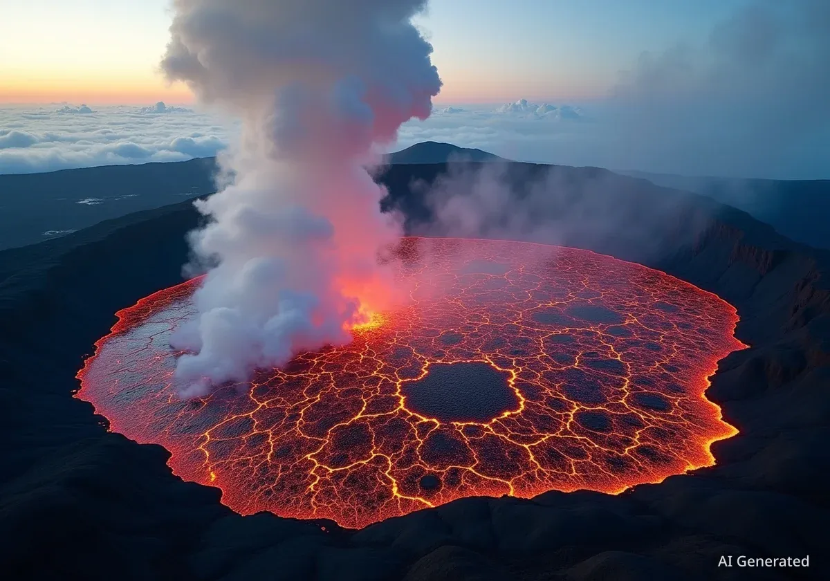


An advanced satellite from the European Space Agency's Copernicus program has captured a striking image of ongoing volcanic activity at Kilauea on Hawaii's Big Island. The image, taken on September 3, 2025, provides a clear view of a large lava lake within the volcano's main crater, highlighting the crucial role of Earth observation in monitoring natural hazards.
The data collected by the Sentinel-2 satellite offers valuable insights into the current eruptive phase, which began in late 2024. By using specialized imaging technology, scientists can track the flow of molten rock and assess the situation from a safe distance, ensuring public safety and improving scientific understanding of volcanic processes.
Key Takeaways
- The Copernicus Sentinel-2 satellite imaged a 2.5-kilometer-long lava lake at Kilauea on September 3, 2025.
- The current eruption phase began on December 23, 2024, and has remained confined within the summit crater.
- The image combines natural color with shortwave infrared data to highlight the intense heat of the lava flows.
- This activity is contrasted with the highly destructive Kilauea eruption of May 2018, which destroyed over 600 homes.
- Satellite technology is essential for monitoring volcanic activity, including lava flows, smoke plumes, and ground changes.
A High-Resolution View from Space
The image released by the European Space Agency (ESA) was acquired by the Copernicus Sentinel-2 satellite, a mission designed for high-resolution optical imaging. Captured from an altitude of approximately 786 kilometers, the picture reveals a lava lake measuring about 2.5 kilometers in length inside Kilauea's Halemaʻumaʻu crater.
This detailed snapshot was taken one day after a significant eruptive episode. On September 2, 2025, lava fountains reportedly reached heights of up to 100 meters, feeding the molten lake visible in the satellite data. Plumes of volcanic gas and smoke can also be seen rising from the crater, drifting with the prevailing winds.
Advanced Imaging Technology
To create the vivid depiction of the volcanic activity, the ESA processed the satellite data using multiple light spectrums. While the image is presented in natural color, it is enhanced with information from the satellite's shortwave infrared (SWIR) channels.
The SWIR channels are specifically designed to detect heat signatures on the Earth's surface. In this image, they were used to highlight the extreme temperatures of the flowing lava, which appears in bright orange and red, contrasting sharply with the darker, cooler volcanic rock surrounding it.
This technique allows scientists and disaster management agencies to accurately map the extent of active lava flows, even through smoke or steam. It provides a clear and immediate assessment of the most active areas within the eruption zone.
Context of the Current Eruption
The current eruptive phase at Kilauea began on December 23, 2024, and has continued with varying intensity throughout 2025. The activity captured in the September image is part of this ongoing sequence, characterized by repeated episodes of lava fountaining and flow within the summit crater.
According to geological assessments, the present eruption is contained within the boundaries of Hawaiʻi Volcanoes National Park and does not currently pose a direct threat to nearby communities. This is a significant distinction from previous, more hazardous events.
"Unlike the event pictured here, which was confined within the summit’s crater and posed little threat to the nearby communities, the eruption that began in May 2018 was one of the most destructive in Kilauea’s recorded history."
The 2018 eruption serves as a stark reminder of Kilauea's power. That event destroyed more than 600 homes and released an enormous volume of lava, estimated to be equivalent to 320,000 Olympic-sized swimming pools. The flows from that eruption significantly reshaped the island's landscape, creating new land along the coast.
Kilauea: One of the World's Most Active Volcanoes
Kilauea is located on the southeastern part of the Big Island of Hawaii. The Hawaiian Islands were formed by a volcanic hotspot in the Pacific Plate, leading to the creation of massive shield volcanoes. Kilauea is the youngest and most active of these, with a history of frequent and sometimes prolonged eruptions.
The Broader Hawaiian Landscape
The Sentinel-2 image also provides a wider view of the unique geography of the Big Island. The dark brown and black areas on the southern flanks of the crater are evidence of past lava flows that have solidified into volcanic rock. This rugged terrain stands in contrast to the lush green vegetation seen across other parts of the island.
Several factors contribute to this vibrant ecosystem:
- Fertile Volcanic Soil: Weathered lava breaks down into nutrient-rich soil, ideal for plant growth.
- Heavy Rainfall: The Pacific trade winds bring significant moisture, which condenses as it rises over the island's mountains, resulting in tropical forests.
- Human Settlement: Lighter green and yellow patches visible to the north of the crater indicate areas of human activity, including settlements, roads, and agricultural plantations.
The presence of clouds scattered throughout the image is also a typical feature of the region's climate, a direct result of the interaction between the ocean winds and the island's high volcanic peaks.
The Importance of Satellite Monitoring
Events like the eruption at Kilauea underscore the critical importance of continuous Earth observation from space. Satellite missions such as Copernicus Sentinel-2 are indispensable tools for volcanologists and emergency responders.
These orbiting platforms provide a consistent and safe method for monitoring volcanic hazards. They can detect and track a range of phenomena associated with eruptions, including:
- Lava Flows: Infrared sensors can map the extent and direction of molten rock.
- Smoke and Ash Plumes: Satellites track the movement of volcanic ash, which is a major hazard to aviation.
- Ground Deformation: Precise instruments can detect subtle swelling or sinking of the ground, indicating magma movement beneath the surface.
- Landslides and Mudflows: Post-eruption monitoring helps identify secondary risks, especially during heavy rainfall.
By providing timely and accurate data, satellite programs like Copernicus empower authorities to make informed decisions, issue warnings, and ultimately protect lives and infrastructure on the ground. The ongoing observation of Kilauea is a clear example of this vital capability in action.