
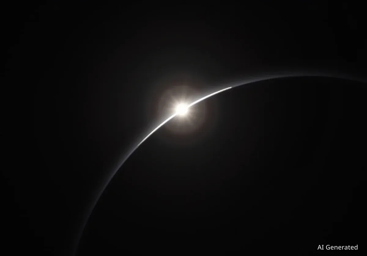


The National Oceanic and Atmospheric Administration's (NOAA) GOES-19 satellite has captured a remarkable image of the partial solar eclipse that occurred on September 21, 2025. The view, taken from its position high above Earth, offers a unique perspective on the celestial event, highlighting the capabilities of modern environmental monitoring technology.
Key Takeaways
- NOAA's GOES-19 satellite captured an image of the September 2025 partial solar eclipse.
- The image was taken using the satellite's Solar Ultraviolet Imager (SUVI), which primarily monitors the sun's atmosphere.
- GOES-19 is a geostationary satellite orbiting approximately 22,236 miles (35,880 km) above the Earth.
- The satellite is part of the GOES-R series, crucial for weather forecasting and monitoring space weather phenomena.
A New Perspective on a Celestial Event
While many observers on Earth watched the partial solar eclipse on September 21, a different view was being recorded from space. The GOES-19 satellite, a key asset in weather and environmental monitoring, documented the moon passing in front of the sun from its unique vantage point.
The resulting image shows the dark silhouette of the moon obscuring a portion of the sun. This perspective, free from atmospheric distortion, provides valuable data for scientists and offers the public a striking visual of the solar system in motion. The image was shared publicly, demonstrating how space-based instruments contribute to our understanding of familiar astronomical events.
What is a Partial Solar Eclipse?
A partial solar eclipse occurs when the moon passes between the sun and Earth, but the three bodies are not perfectly aligned. From an observer's perspective, the moon only partially covers the sun's disk. This differs from a total solar eclipse, where the moon completely blocks the sun for a brief period.
The GOES-19 Satellite Mission
The GOES-19, also known as GOES-EAST, is a sophisticated weather satellite operated by NOAA. It is part of the Geostationary Operational Environmental Satellite (GOES)-R Series, which represents a significant advancement in weather observation and forecasting technology.
Launched in June 2024 aboard a SpaceX Falcon Heavy rocket, GOES-19 became fully operational in April 2025. It took over from the older GOES-16 satellite, continuing the mission of providing critical data for the United States. The satellite works in tandem with GOES-18 (GOES-WEST) to provide continuous coverage of more than half the globe, from the west coast of Africa to New Zealand.
Key Functions of GOES-19
The primary mission of GOES-19 is to supply accurate, real-time data for a variety of purposes. Its monitoring capabilities include:
- Weather Monitoring: Tracking storm systems, hurricanes, and other severe weather.
- Environmental Hazards: Detecting wildfires, volcanic ash clouds, and areas of drought.
- Oceanic Conditions: Observing sea surface temperatures and ocean currents.
- Solar and Space Weather: Monitoring solar flares, coronal mass ejections, and other solar phenomena that can impact technology on Earth.
High-Altitude Orbit
GOES-19 maintains a geostationary orbit at an altitude of approximately 22,236 miles (35,880 kilometers) above the Earth's equator. At this height, its orbital period matches Earth's rotation, allowing it to remain in a fixed position relative to the surface and continuously monitor the same geographic area.
How the Eclipse Image Was Captured
The stunning image of the solar eclipse was captured not by a standard camera, but by a specialized instrument called the Solar Ultraviolet Imager (SUVI). This device is a key component of the satellite's space weather monitoring payload.
The SUVI's main purpose is to observe the sun's extremely hot outer atmosphere, known as the corona. It captures full-disk images of the sun in multiple extreme ultraviolet (EUV) wavelengths. According to NOAA, this capability is essential for the early detection of solar flares, erupting filaments, and other solar events that can trigger geomagnetic storms.
While its primary function is to watch for solar activity, the SUVI's constant observation of the sun makes it perfectly positioned to capture events like solar eclipses. The instrument provided a clear view of the moon transiting across the solar disk, an event that is both scientifically interesting and visually compelling.
The Importance of Space-Based Observation
Capturing events like this solar eclipse underscores the value of maintaining a constant watch on the sun and its surrounding environment. Satellites like GOES-19 are our first line of defense against hazardous space weather, which can disrupt power grids, satellite communications, and GPS navigation systems.
The data collected by the SUVI and other instruments helps scientists understand the complex dynamics of the sun and improve space weather forecasting models. These images serve as a powerful reminder of the interconnectedness of Earth and the wider solar system, and the critical role that technology plays in monitoring our cosmic neighborhood.
Beyond its scientific applications, the imagery produced by missions like GOES-19 inspires public interest in science and space exploration. It provides a shared experience, connecting people on the ground with the advanced technology orbiting far above.