
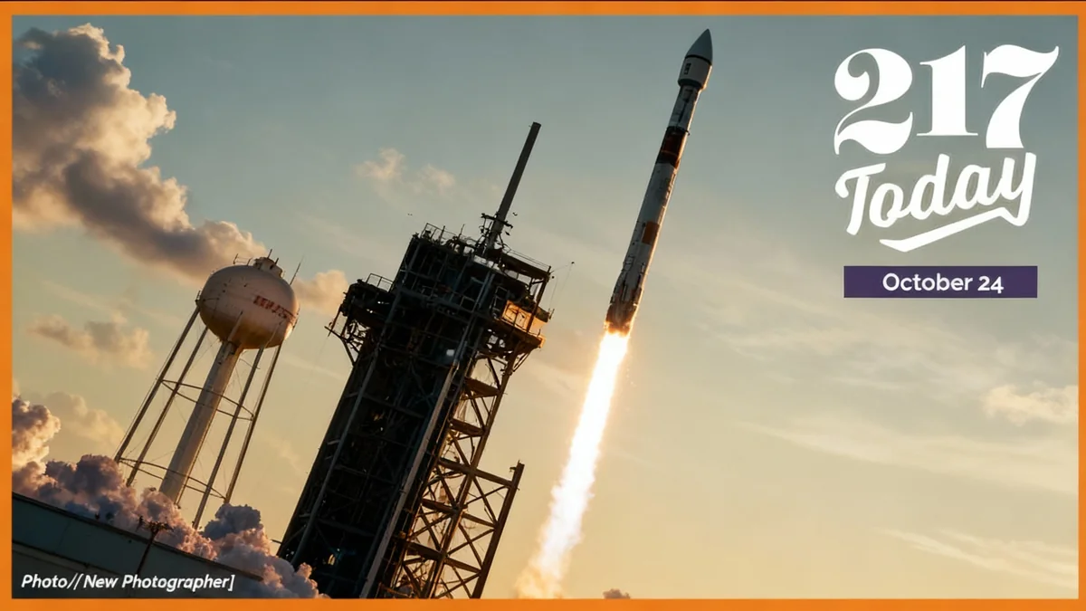

A small satellite designed and built at the University of Illinois Urbana-Champaign is now in orbit, tasked with studying the complex dynamics of space weather. The device was successfully deployed after launching as a secondary payload aboard a SpaceX Falcon 9 rocket from Kennedy Space Center in Florida last month.
The mission's primary goal is to gather data on how solar activity and other atmospheric phenomena impact critical infrastructure on Earth. This research aims to improve our ability to predict and mitigate the effects of space weather on everything from GPS navigation to power grids.
Key Takeaways
- A University of Illinois-designed satellite has been successfully placed into orbit.
- The mission will focus on studying space weather and its effects on Earth-based technology.
- It launched on September 24, 2025, from Kennedy Space Center as a secondary payload.
- The data collected is expected to help protect essential services like GPS and electrical grids from solar disruptions.
The Mission's Scientific Goals
The satellite's journey began on September 24, 2025, when it lifted off from Cape Canaveral. While the rocket's main objective was to deliver the Interstellar Mapping and Acceleration Probe (IMAP), the Illinois-built device was part of a rideshare mission, a cost-effective way to get smaller research projects into space.
Now in Earth's outer atmosphere, the satellite will begin its core mission: observing the volatile environment of near-Earth space. This region is constantly influenced by the Sun, which emits a continuous stream of charged particles known as the solar wind. When this activity intensifies during events like solar flares or coronal mass ejections, it can have significant consequences for our planet.
Protecting Our Technological Backbone
Modern society is heavily dependent on technology that is vulnerable to space weather. Satellites that provide communication, navigation, and weather forecasting services can be damaged or disabled by intense solar radiation. On the ground, electrical power grids can experience surges that lead to widespread blackouts.
Did You Know?
Severe space weather events have caused major disruptions in the past. In 1989, a geomagnetic storm knocked out the power grid across Quebec, Canada, leaving millions without electricity for hours. More recently, solar storms have been linked to disruptions in satellite communications and GPS accuracy.
By collecting real-time data from orbit, researchers at the University of Illinois hope to build more accurate models of space weather. Improved forecasting could give satellite operators and utility companies advance warning to take protective measures, safeguarding essential services for millions of people.
A University-Led Initiative in Space
The development of this satellite represents a significant achievement for the University of Illinois Urbana-Champaign, which has a long history of contributions to space science and engineering. The project involved students and faculty, providing hands-on experience in designing, building, and testing hardware for the harsh environment of space.
These types of university-led projects are becoming increasingly important in the field of space research. They serve as a vital training ground for the next generation of aerospace engineers and scientists while producing valuable scientific data at a fraction of the cost of larger, government-led missions.
The Rise of Small Satellites
The mission is part of a growing trend in space exploration that utilizes smaller, more specialized satellites, often called CubeSats or smallsats. These compact devices can be developed and launched more quickly and affordably than traditional satellites, allowing universities, research institutions, and even private companies to conduct experiments in orbit.
The data from the Illinois satellite will be transmitted back to a ground station at the university, where it will be analyzed by the research team. The findings will be made available to the broader scientific community to help advance global understanding of the Sun-Earth connection.
Launch and Deployment Details
The satellite's journey to orbit was a carefully orchestrated event. It was carried into space by a SpaceX Falcon 9, a reusable two-stage rocket that has become a workhorse for both commercial and scientific payloads.
The launch took place from the historic Launch Pad 39A at Kennedy Space Center, the same site used for the Apollo moon missions. After reaching its designated altitude, the primary IMAP payload was deployed. Sometime later, the University of Illinois satellite was released from its dispenser to begin its independent mission.
What Happens Next?
With the satellite now operational, the first phase involves a series of checks to ensure all systems are functioning correctly after the rigors of launch. The team will confirm that the satellite is receiving power, communicating with the ground, and that its scientific instruments are calibrated.
Once this commissioning phase is complete, the satellite will begin its scientific operations. Over the course of its mission, it will gather continuous data on the plasma, magnetic fields, and energetic particles that characterize space weather. This long-term monitoring is crucial for understanding how these conditions evolve over time.
"Understanding space weather is no longer an academic exercise; it is a matter of national security and economic stability. Projects like this provide the critical data we need to protect our infrastructure from the effects of the Sun."
The success of this launch marks another step forward in our ability to monitor and predict the complex forces that shape our planet's atmospheric environment. The insights gained from this small but powerful satellite will contribute to a safer and more resilient technological future.